Large Language Models
Abschnittsübersicht
-
This tutorial introduces the fundamentals of Large Language Models (LLMs), explaining how they are trained and how they generate text. It discusses the main limitations of LLMs and explores ways to extend their capabilities through external tools and data integration. You will learn how to leverage LLMs for spatial analysis by generating and executing PyQGIS code, and how to build an AI agent using the smolagents framework to automate and enhance geospatial workflows.
The tutorial is structured as follows:
-
Overview
-
Background
-
How Large Language Models are created
-
Pre-training
-
Fine-tuning and instruction tuning
-
Reinforcement Learning from Human Feedback (RLHF)
-
How Large Language Models generate text
-
Reasoning Models
-
Model Distillation
-
Multimodal LLMs
-
Limitations of LLMs
-
Extending LLM Capabilities
-
Tools, Frameworks, and Software for working with LLMs
-
Practical Exercises
-
Using LLMs to perform Spatial Analysis
-
Setting up the environment and data
-
Performing Accessibility analysis using an LLM
-
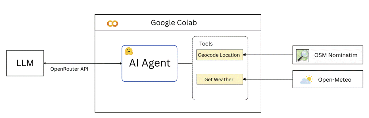
Creating an AI Agent
-
Setting up the Google Colab environment
-
Creating tools and running the AI Agent
-
Discussion and Conclusion
-
References
Target Audience and Prerequisites
This tutorial is designed for students and professionals who want to improve their understanding of LLMs and some of their applications in the Geoinformatics domain. Some basic knowledge of QGIS and Python is beneficial. However, you can still proceed with limited knowledge of these areas, as this tutorial provides the required code and the QGIS steps to follow.
You will need about 120 minutes to work through this tutorial.
How to use the OER module
Simply download the PDF file, read and follow the tutorial.
Authors
This OER module has been developed at 52°North Spatial Information Research GmbH in collaboration with the Institute for Geoinformatics (IFGI) at the University of Münster. Authors are James Ondieki, Albert Remke, and Simon Jirka.
License Statement
You are free to use, alter and share the content of the tutorial under the terms of the CC-BY-SA 4.0 license, unless explicitly stated otherwise for specific parts of the content. All logos used are generally excluded.
Any code provided with the tutorial can be used under the terms of the MIT license. Please see the full license terms: https://github.com/oer4sdi/OER-LLMs/blob/master/LICENSE.md.
The tutorial can be referenced as follows: “OER-LLMs”, OER4SDI project / University Münster, CC BY-SA 4.0.
-